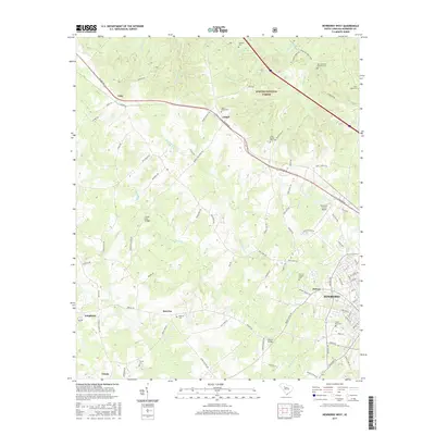
2017 Map of Newberry West
USGS Topo · Published 2017About this map
Sumter National Forest land dominates the northern portion of this area, where the terrain is drained by tributaries like Johns Mountain Br and Joshua Br. The settlement of Jalapa serves as a central point along the path of Wilson Rd, while the western edge of Newberry and the community of Helena occupy the southeastern corner. This survey documents the landscape's transition from forest and agriculture to the suburban fringes and aviation infrastructure at the Newberry County Airport.
Find a feature on this map
100 named features on this map. Tap any name to fly to it.
Don’t see what you’re looking for? This feature index may not catch every label — zoom into the map to look around manually.
Map Details
Editions of this 2017 Newberry West Map
This is the sole edition of this map. No revisions or reprints were ever made.
Other maps of this area

1941 · Spartanburg
USGS Topo · 1:250,000

1953 · Spartanburg
USGS Topo · 1:250,000

1960 · Spartanburg
USGS Topo · 1:250,000

1963 · Spartanburg
USGS Topo · 1:250,000

1964 · Spartanburg
USGS Topo · 1:250,000

1968 · Newberry East
USGS Topo · 1:24,000

1969 · Whitmire South
USGS Topo · 1:24,000

1969 · Newberry NW
USGS Topo · 1:24,000

1969 · Newberry West
USGS Topo · 1:24,000
1970 · Prosperity
USGS Topo · 1:24,000