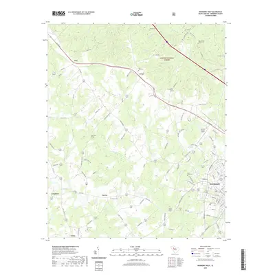
2020 Map of Newberry West
USGS Topo · Published 2020About this map
Sumter National Forest land dominates the northern portion of this landscape, where the upper reaches of Bush River are fed by numerous small tributaries like Johns Mountain Br and David Br. This map illustrates the rural character of western Newberry County, showing a network of small settlements and church-centered communities such as Jalapa, Gary, and Smyrna. The proximity of the city of Newberry is evident in the southeastern corner, where the infrastructure transition from forest and farm to more dense development appears around Helena and the Newberry County Airport. Local history is preserved in the numerous burial grounds scattered across the area, including Saint James Cem near the Wilson Road corridor and Tranquil Cem to the north. Transportation patterns are defined by historic routes like Wilson Rd and the presence of localized landmarks such as Sends Mill Bridge, which once served as a vital crossing over the winding Bush River.
Find a feature on this map
101 named features on this map. Tap any name to fly to it.
Don’t see what you’re looking for? This feature index may not catch every label — zoom into the map to look around manually.
Map Details
Editions of this 2020 Newberry West Map
This is the sole edition of this map. No revisions or reprints were ever made.
Other maps of this area

1941 · Spartanburg
USGS Topo · 1:250,000

1953 · Spartanburg
USGS Topo · 1:250,000

1960 · Spartanburg
USGS Topo · 1:250,000

1963 · Spartanburg
USGS Topo · 1:250,000

1964 · Spartanburg
USGS Topo · 1:250,000

1968 · Newberry East
USGS Topo · 1:24,000

1969 · Whitmire South
USGS Topo · 1:24,000

1969 · Newberry NW
USGS Topo · 1:24,000

1969 · Newberry West
USGS Topo · 1:24,000
1970 · Prosperity
USGS Topo · 1:24,000