
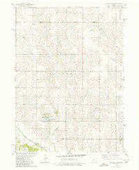
1980 Map of Newburg
USGS Topo · Published 1980About this map
Rock Creek State Park anchors the southwestern portion of this map, surrounding the waters of Rock Creek Lake where it was dammed in the rolling landscape of central Iowa. The settlement of Newburg sits along the Chicago and North Western railroad line, serving as a primary transit point for the surrounding agricultural townships. The terrain is defined by the headwaters and branches of several drainage systems, including Rock Creek, Brush Creek, and Bear Creek, which carve through the land at the intersection of four counties. Local landmarks such as Hickory Grove Ch and Mt Pleasant Ch indicate the social centers for the farming community during this era. The map provides a detailed view of the rural infrastructure, from the picnic areas and campgrounds at the state park to the municipal utilities serving the small population centers.
Find a feature on this map
25 named features on this map. Tap any name to fly to it.
Don’t see what you’re looking for? This feature index may not catch every label — zoom into the map to look around manually.
Map Details
Editions of this 1980 Newburg Map
This is the sole edition of this map. No revisions or reprints were ever made.
Other maps of this area

1954 · Des Moines
USGS Topo · 1:250,000

1956 · Des Moines
USGS Topo · 1:250,000

1957 · Des Moines
USGS Topo · 1:250,000

1969 · Des Moines
USGS Topo · 1:250,000

1979 · Grinnell South
USGS Topo · 1:24,000
1980 · Montour
USGS Topo · 1:24,000
1980 · Gilman
USGS Topo · 1:24,000
1980 · Laurel
USGS Topo · 1:24,000
1980 · Grinnell North
USGS Topo · 1:24,000
1980 · Alloway Creek
USGS Topo · 1:24,000
Featured Places
- Gilman, Greencastle Township
- Rock Creek Township, IA
- Hickory Grove Township, IA
- Greencastle Township, IA
- Newburg, Hickory Grove Township