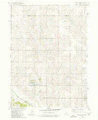
1980 Map of Alloway Creek
USGS Topo · Published 1980About this map
Mariposa County Park serves as a central landmark in this 1980 survey of the Jasper and Marshall county line, featuring the waters of Ken Wolfe Lake and dedicated Picnic Area and Campground facilities. The landscape is defined by the dendritic drainage patterns of the North Skunk River and its numerous tributaries, including Alloway Creek, Potato Creek, and the various branches of Burr Oak Creek.
Find a feature on this map
21 named features on this map. Tap any name to fly to it.
Don’t see what you’re looking for? This feature index may not catch every label — zoom into the map to look around manually.
Map Details
Editions of this 1980 Alloway Creek Map
This is the sole edition of this map. No revisions or reprints were ever made.
Other maps of this area

1954 · Des Moines
USGS Topo · 1:250,000

1956 · Des Moines
USGS Topo · 1:250,000

1957 · Des Moines
USGS Topo · 1:250,000

1965 · Newton
USGS Topo · 1:24,000

1969 · Des Moines
USGS Topo · 1:250,000
1975 · Melbourne
USGS Topo · 1:24,000

1975 · Baxter SE
USGS Topo · 1:24,000

1980 · Newburg
USGS Topo · 1:24,000
1980 · Gilman
USGS Topo · 1:24,000
1980 · Laurel
USGS Topo · 1:24,000
Featured Places
- Kellogg Township, IA
- Malaka Township, IA
- Rock Creek Township, IA
- Hickory Grove Township, IA
- Jefferson Township, IA