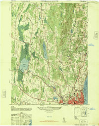
1947 Map of Newburgh North
USGS Topo · Published 1947About this map
The northern reaches of Newburgh and its surrounding rural hamlets are captured in this mid-century portrait of Orange and Ulster counties. The landscape is defined by the prominent ridge of Marlboro Mountain and the western bank of the Hudson River, where the Hudson Day Line Pier and industrial facilities like the Sinclair Oil Co Bulk Plant indicate a river-dependent economy. Further inland, the transition from residential clusters like Balmville and Middle Hope to the open waters of Chadwick Lake and Orange Lake highlights a region balancing agriculture, early aviation at Stewarts AAF, and seasonal recreation at the Pine Point Casino. Local life is anchored by a dense network of neighborhood schools and churches, including Mt St Marys Academy and several namesake schoolhouses like Fostertown School and Leptondale School, offering a detailed look at the social geography of the era.
Find a feature on this map
41 named features on this map. Tap any name to fly to it.
Don’t see what you’re looking for? This feature index may not catch every label — zoom into the map to look around manually.
Map Details
Editions of this 1947 Newburgh North Map
This is the sole edition of this map. No revisions or reprints were ever made.
Other maps of this area

1892 · West Point
USGS Topo · 1:62,500

1893 · Poughkeepsie
USGS Topo · 1:62,500

1894 · West Point
USGS Topo · 1:62,500

1894 · Poughkeepsie
USGS Topo · 1:62,500

1899 · West Point
USGS Topo · 1:62,500

1901 · West Point
USGS Topo · 1:62,500

1902 · Schunemunk
USGS Topo · 1:62,500

1903 · Poughkeepsie
USGS Topo · 1:62,500

1903 · Newburg
USGS Topo · 1:62,500

1930 · Schunemunk
USGS Topo · 1:48,000