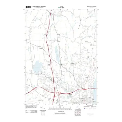
2010 Map of Newburgh
USGS Topo · Published 2010About this map
Newburgh is the hub of this Hudson Valley landscape, where the historic waterfront meets modern infrastructure. The city's dense urban layout near the Hudson River is detailed alongside vital transport links like the Newburgh And Beacon Ferry and the expansive Stewart International Airport. Beyond the city center, the terrain rises toward Marlboro Mountain and Cronomer Hill, punctuated by established residential areas and family-named agricultural sites. Agricultural roots are visible at Gardnertown Farms and Lawrence Farms Orchards, while the region's spiritual and community history is anchored by Saint Mary of the Angels Camp and several prominent burial grounds, including Oldtown Cemetery and Saint Patrick's Cemetery. Water management and natural features like Chaddwick Lake and Orange Lake shape the outlying settlements of Cronomer Valley and Leptondale, illustrating a century of growth from riverport to a complex suburban and industrial corridor.
Find a feature on this map
81 named features on this map. Tap any name to fly to it.
Don’t see what you’re looking for? This feature index may not catch every label — zoom into the map to look around manually.
Map Details
Editions of this 2010 Newburgh Map
This is the sole edition of this map. No revisions or reprints were ever made.
Other maps of this area

1892 · West Point
USGS Topo · 1:62,500

1893 · Poughkeepsie
USGS Topo · 1:62,500

1894 · West Point
USGS Topo · 1:62,500

1894 · Poughkeepsie
USGS Topo · 1:62,500

1899 · West Point
USGS Topo · 1:62,500

1901 · West Point
USGS Topo · 1:62,500

1902 · Schunemunk
USGS Topo · 1:62,500

1903 · Poughkeepsie
USGS Topo · 1:62,500

1903 · Newburg
USGS Topo · 1:62,500

1930 · Schunemunk
USGS Topo · 1:48,000