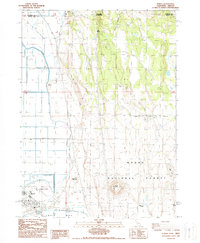
1988 Map of Newell
USGS Topo · Published 1988About this map
Newell anchors the southwestern corner of this high-desert landscape near the California-Oregon border, where the industrial infrastructure of the Tulelake basin meets the rising volcanic terrain of the Modoc National Forest. The map illustrates a complex network of irrigation and reclamation, featuring numerous ditches, the canal system, and a prominent levee and spoil bank bordering Copic Bay. This engineering effort supports the local aviation and agricultural hub at Tulelake Airport.
Find a feature on this map
42 named features on this map. Tap any name to fly to it.
Don’t see what you’re looking for? This feature index may not catch every label — zoom into the map to look around manually.
Map Details
Editions of this 1988 Newell Map
This is the sole edition of this map. No revisions or reprints were ever made.
Other maps of this area

1886 · Modoc Lava Bed
USGS Topo · 1:250,000

1889 · Klamath
USGS Topo · 1:250,000

1892 · Modoc Lava-Bed
USGS Topo · 1:250,000

1894 · Klamath
USGS Topo · 1:250,000

1951 · Clear Lake Reservoir
USGS Topo · 1:62,500

1951 · Tulelake
USGS Topo · 1:62,500

1954 · Alturas
USGS Topo · 1:250,000

1955 · Klamath Falls
USGS Topo · 1:250,000

1957 · Malin
USGS Topo · 1:62,500

1958 · Alturas
USGS Topo · 1:250,000