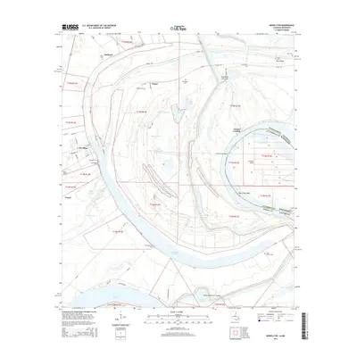
2015 Map of Newellton
USGS Topo · Published 2015About this map
Newellton and the surrounding alluvial lands of Tensas Parish are defined by the winding course of the Mississippi River and its intricate network of oxbow lakes and sloughs. The town of Newellton serves as the local center, situated near the western edge of the quadrangle and supported by Kifer Airport. To the east, the landscape transitions into a complex of water bodies including Lake Saint Joseph, Yucatan Lake, and Johnson Lake, illustrating the river's historical shifts and the flood-prone nature of the delta. Local genealogy and settlement history are rooted in the numerous burial grounds scattered across the terrain, such as Wyoming Cem, Bland Cem, and Saint Matthew Cem. The presence of features like Buckridge Crevasse and Winter Quarters Crevasse highlights the ongoing struggle with the river's power, while place names like Yucatan Landing and Balmoral point to the area's agricultural and riverboat heritage.
Find a feature on this map
89 named features on this map. Tap any name to fly to it.
Don’t see what you’re looking for? This feature index may not catch every label — zoom into the map to look around manually.
Map Details
Editions of this 2015 Newellton Map
This is the sole edition of this map. No revisions or reprints were ever made.
Other maps of this area

1909 · Delta Bridge
USGS Topo · 1:24,000

1909 · Lake Bruen
USGS Topo · 1:24,000

1935 · Shackleford Lake
USGS Topo · 1:62,500

1939 · Lorman
USGS Topo · 1:62,500

1939 · Locust Ridge
USGS Topo · 1:62,500

1953 · Natchez
USGS Topo · 1:250,000

1955 · Jackson
USGS Topo · 1:250,000

1956 · Natchez
USGS Topo · 1:250,000

1958 · Shackleford Lake
USGS Topo · 1:62,500

1958 · St. Joseph
USGS Topo · 1:62,500