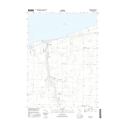
2016 Map of Newfane
USGS Topo · Published 2016About this map
Eighteenmile Creek and Keg Cr carve through the Niagara County landscape as they flow north toward the expansive shoreline of Lake Ontario. This 2016 survey highlights the agricultural and residential corridors of northern New York, anchored by the lakeside community of Olcott and the inland settlements of Burt and Newfane. The local infrastructure is defined by a dense grid of rural routes such as Drake Settlement Rd and Transit Rd, connecting family-named landmarks and historic grounds. Genealogists will find several burial sites preserved across the township, including Saint Charles Cem and Corwin Cem near the southern boundary, alongside the Hess Cem to the east. The presence of the Olcott-Newfane Airport and the distinct elevation of Golden Hill further distinguish this lakefront region, illustrating a modern balance of transportation and natural topography.
Find a feature on this map
64 named features on this map. Tap any name to fly to it.
Don’t see what you’re looking for? This feature index may not catch every label — zoom into the map to look around manually.
Map Details
Editions of this 2016 Newfane Map
This is the sole edition of this map. No revisions or reprints were ever made.
Other maps of this area

1894 · Wilson
USGS Topo · 1:62,500

1897 · Tonawanda
USGS Topo · 1:62,500

1897 · Olcott
USGS Topo · 1:62,500

1897 · Lockport
USGS Topo · 1:62,500

1899 · Niagara
USGS Topo · 1:125,000

1900 · Wilson
USGS Topo · 1:62,500

1900 · Tonawanda
USGS Topo · 1:62,500

1901 · Tonawanda
USGS Topo · 1:62,500

1902 · Lockport
USGS Topo · 1:62,500

1905 · Lockport
USGS Topo · 1:62,500