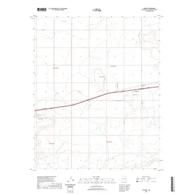
2020 Map of Newkirk
USGS Topo · Published 2020About this map
Newkirk centers this high-desert landscape in Guadalupe County, where the transportation corridor of the Southwest dominates the terrain. The community is positioned along Main ST and the modern interstate frontage, bordered to the south by the extensive elevations of Cuervo Mesa. The local geography is defined by seasonal watercourses like Pajarito Cr and Difrises Arroyo, which cut through the arid plains surrounding Mesa del Gato. Local family names and history are preserved in the road network, including Pedro Romero Rd and Gilbert Sena Rd, and the Newkirk Cem located just east of the primary settlement. This survey illustrates the spatial relationship between these rural access roads and the land divisions of townships T9N and T10N, reflecting a modern cattle-country economy structured around early homesteading boundaries.
Find a feature on this map
18 named features on this map. Tap any name to fly to it.
Don’t see what you’re looking for? This feature index may not catch every label — zoom into the map to look around manually.
Map Details
Editions of this 2020 Newkirk Map
This is the sole edition of this map. No revisions or reprints were ever made.
Other maps of this area

1954 · Santa Fe
USGS Topo · 1:250,000

1954 · Fort Sumner
USGS Topo · 1:250,000

1958 · Fort Sumner
USGS Topo · 1:250,000

1958 · Santa Fe
USGS Topo · 1:250,000

1963 · Mesita Del Gato
USGS Topo · 1:24,000

1963 · Cuervo
USGS Topo · 1:24,000

1964 · Neafus Ranch
USGS Topo · 1:24,000

1964 · Gate Canyon
USGS Topo · 1:24,000

1964 · Newkirk
USGS Topo · 1:24,000
1964 · Salt Lake
USGS Topo · 1:24,000