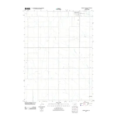
2011 Map of Newman Grove
USGS Topo · Published 2011About this map
Newman Grove sits at the northern edge of this agricultural landscape, anchored by the Newman Grove Post Office and the local Hope Cemetery. The town's grid is bounded by Railroad Ave, reflecting its historic connection to the rail corridors that shaped the settlement patterns of Madison County. South of town, the landscape is defined by the winding course of Looking Glass Creek, which meanders through a structured network of section roads like Co Line Rd and 400 St. Near the southeastern corner of the map, the small settlement of Rosenburg marks an intersection in the rural grid, while Shell Creek flows through the northeastern corner. The precision of the grid-line roads, including 536 Ave and 490 St, illustrates the enduring influence of the Public Land Survey System on the Nebraska prairie into the early 21st century.
Find a feature on this map
20 named features on this map. Tap any name to fly to it.
Don’t see what you’re looking for? This feature index may not catch every label — zoom into the map to look around manually.
Map Details
Editions of this 2011 Newman Grove Map
This is the sole edition of this map. No revisions or reprints were ever made.
Other maps of this area

1955 · Fremont
USGS Topo · 1:250,000

1957 · Fremont
USGS Topo · 1:250,000

1958 · Fremont
USGS Topo · 1:250,000

1958 · St. Edward
USGS Topo · 1:24,000

1958 · Albion East
USGS Topo · 1:24,000
1958 · St. Edward SW
USGS Topo · 1:24,000

1963 · Closter SW
USGS Topo · 1:24,000

1963 · Closter SE
USGS Topo · 1:24,000

1963 · Battle Creek SW
USGS Topo · 1:24,000
1966 · Newman Grove
USGS Topo · 1:24,000