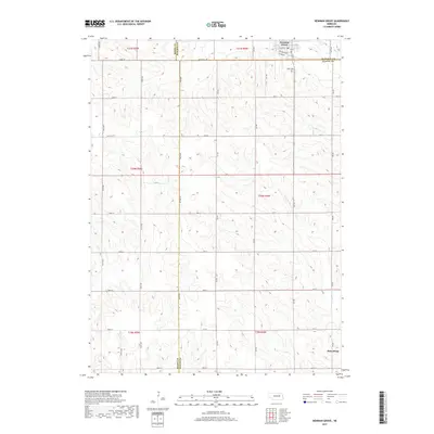
2017 Map of Newman Grove
USGS Topo · Published 2017About this map
Newman Grove sits at the intersection of Madison and Platte counties, serving as a concentrated hub of local activity amidst the vast section-line grid of the Nebraska prairie. The town layout is clearly defined by residential streets like Hale Ave and Logan Ave, alongside Railroad Ave which signals the historical importance of the rail corridor through this agricultural region. To the southeast, the small settlement of Rosenburg anchors the lower reaches of the map near the border of Madison County. The landscape is primarily shaped by the winding paths of Looking Glass Creek and Shell Creek, which cut through the rolling terrain. Cultural landmarks such as Hope Cem provide points of interest for genealogists tracing family roots in this rural township environment, while the intricate network of numbered avenues and named routes like Poker Hill Rd illustrates the mature development of local transit and land management.
Find a feature on this map
47 named features on this map. Tap any name to fly to it.
Don’t see what you’re looking for? This feature index may not catch every label — zoom into the map to look around manually.
Map Details
Editions of this 2017 Newman Grove Map
This is the sole edition of this map. No revisions or reprints were ever made.
Other maps of this area

1955 · Fremont
USGS Topo · 1:250,000

1957 · Fremont
USGS Topo · 1:250,000

1958 · Fremont
USGS Topo · 1:250,000

1958 · St. Edward
USGS Topo · 1:24,000

1958 · Albion East
USGS Topo · 1:24,000
1958 · St. Edward SW
USGS Topo · 1:24,000

1963 · Closter SW
USGS Topo · 1:24,000

1963 · Closter SE
USGS Topo · 1:24,000

1963 · Battle Creek SW
USGS Topo · 1:24,000
1966 · Newman Grove
USGS Topo · 1:24,000