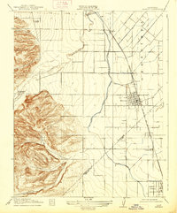
1917 Map of Newman
USGS Topo · Published 1938About this map
The town of Newman serves as the central hub of this 1915 survey, situated at the junction of agricultural expansion and industrial transport. The heavy grid of the township is defined by the Southern Pacific railroad and the San Joaquin and Kings River Irrigation Company Canal, illustrating the vital role of water management in the Central Valley's development. While the eastern flats are carved into neat sections for farming, the western portion of the map rises into the foothills, featuring Orestimba and Poverty Flat.
Find a feature on this map
17 named features on this map. Tap any name to fly to it.
Don’t see what you’re looking for? This feature index may not catch every label — zoom into the map to look around manually.
Map Details
Editions of this 1917 Newman Map
3 editions found
Other maps of this area

1916 · Mitchell School
USGS Topo · 1:31,680

1916 · Crows Landing
USGS Topo · 1:31,680

1916 · Patterson
USGS Topo · 1:31,680

1917 · Newman
USGS Topo · 1:31,680

1918 · Gustine
USGS Topo · 1:31,680

1919 · Orestimba
USGS Topo · 1:62,500

1919 · Orestimba Creek
USGS Topo · 1:31,680

1919 · Ingomar
USGS Topo · 1:31,680

1920 · Pacheco Pass
USGS Topo · 1:62,500

1922 · Howard Ranch
USGS Topo · 1:31,680