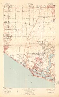
1951 Map of Newport Beach
USGS Topo · Published 1951About this map
The Santa Ana River carves a path through the heart of Orange County in the early 1950s, separating the extensive Oil Wells of Huntington Beach from the developing residential reaches of Costa Mesa. This coastal landscape is defined by its transition from agricultural lands like Silver Acres and Wintersburg to a massive maritime and industrial hub. The intricate waterways of Newport Bay reveal a complex layout of islands, including Lido Isle and Balboa Island, while the presence of three distinct aviation sites — Huntington Beach Airport, Balboa Airport, and Orange Co Airport — signals the region's rapid mid-century expansion. Farther inland, the Pacific Electric rail line and the Naval Reservation provide evidence of the vital transportation and military infrastructure that supported the South Coast during this era.
Find a feature on this map
52 named features on this map. Tap any name to fly to it.
Don’t see what you’re looking for? This feature index may not catch every label — zoom into the map to look around manually.
Map Details
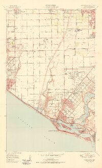
Editions of this 1951 Newport Beach Map
2 editions found
Other maps of this area

1896 · Santa Ana
USGS Topo · 1:62,500

1896 · Anaheim
USGS Topo · 1:62,500

1896 · Las Bolsas
USGS Topo · 1:62,500

1896 · Downey
USGS Topo · 1:62,500

1898 · Anaheim
USGS Topo · 1:62,500

1899 · Downey
USGS Topo · 1:62,500

1901 · Southern California Sheet No. 1
USGS Topo · 1:250,000

1901 · Santa Ana
USGS Topo · 1:62,500

1901 · Anaheim
USGS Topo · 1:62,500

1902 · Downey
USGS Topo · 1:62,500