
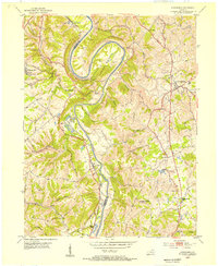
1952 Map of Newport
USGS Topo · Published 1953About this map
The Ohio River and Licking River converge at the heart of this mid-century survey, defining the industrial and residential boundaries of northern Kentucky. Dense urban blocks in Newport, Bellevue, and Dayton contrast with the winding ridges of Fort Thomas and Highland Heights. The map reveals a high concentration of institutional landmarks that shaped local life, including the Good Shepherd Convent, St Joseph Orphanage, and Speers Memorial Hospital. Transport networks are prominently detailed, from the tracks of the Chesapeake and Ohio and Louisville and Nashville railroads to the active river infrastructure at Lock No 36. South of the urban core, the landscape transitions into smaller settlements like Cold Spring and Crestview, while the massive Evergreen Cemetery and various religious centers like St Anne Convent suggest a long-established community structure.
Find a feature on this map
69 named features on this map. Tap any name to fly to it.
Don’t see what you’re looking for? This feature index may not catch every label — zoom into the map to look around manually.
Map Details
Editions of this 1952 Newport Map
This is the sole edition of this map. No revisions or reprints were ever made.
Other maps of this area

1898 · East Cincinnati
USGS Topo · 1:62,500

1914 · East Cincinnati
USGS Topo · 1:62,500

1914 · West Cincinnati
USGS Topo · 1:62,500

1929 · Alexandria
USGS Topo · 1:48,000

1936 · Alexandria
USGS Topo · 1:62,500

1950 · Independence
USGS Topo · 1:24,000

1950 · Covington
USGS Topo · 1:24,000

1953 · Withamsville
USGS Topo · 1:24,000

1953 · New Richmond
USGS Topo · 1:24,000
1953 · Alexandria
USGS Topo · 1:24,000