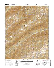
2016 Map of Newport
USGS Topo · Published 2016About this map
Jefferson National Forest dominates the high ridges and steep hollows north of Blacksburg in this 2016 study. The landscape is defined by the massive parallel formations of Johns Creek Mtn, Clover Hollow Mtn, and Brush Mtn, which channel waterways like Sinking Creek and Craig Cr through narrow valleys. This area preserves several historic landmarks, most notably the Sinking Creek Covered Bridge near Newport.
Find a feature on this map
110 named features on this map. Tap any name to fly to it.
Don’t see what you’re looking for? This feature index may not catch every label — zoom into the map to look around manually.
Map Details
Editions of this 2016 Newport Map
This is the sole edition of this map. No revisions or reprints were ever made.
Other maps of this area

1890 · Dublin
USGS Topo · 1:125,000

1890 · Christiansburg
USGS Topo · 1:125,000

1891 · Dublin
USGS Topo · 1:125,000

1923 · Pearisburg
USGS Topo · 1:62,500

1923 · Waiteville
USGS Topo · 1:62,500

1931 · Waiteville
USGS Topo · 1:48,000

1932 · Pearisburg
USGS Topo · 1:48,000

1932 · Blacksburg
USGS Topo · 1:48,000

1937 · Pearisburg
USGS Topo · 1:62,500

1937 · Blacksburg
USGS Topo · 1:62,500