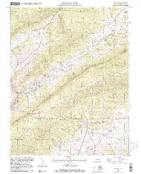
1998 Map of Newport
USGS Topo · Published 2000About this map
The Jefferson National Forest dominates this section of the Appalachian highlands, where the ridgelines of Sinking Creek Mountain and Brush Mountain run parallel through Montgomery, Giles, and Craig counties. The landscape is defined by its deep hollows and the winding course of Sinking Creek, which flows past the settlement of Newport and its historic Covered Bridge. This area serves as a significant corridor for the Appalachian National Scenic Trail, winding through high elevations near Kelly Knob and Wolf Knob.
Find a feature on this map
47 named features on this map. Tap any name to fly to it.
Don’t see what you’re looking for? This feature index may not catch every label — zoom into the map to look around manually.
Map Details
Editions of this 1998 Newport Map
This is the sole edition of this map. No revisions or reprints were ever made.
Other maps of this area

1890 · Dublin
USGS Topo · 1:125,000

1890 · Christiansburg
USGS Topo · 1:125,000

1891 · Dublin
USGS Topo · 1:125,000

1923 · Pearisburg
USGS Topo · 1:62,500

1923 · Waiteville
USGS Topo · 1:62,500

1931 · Waiteville
USGS Topo · 1:48,000

1932 · Pearisburg
USGS Topo · 1:48,000

1932 · Blacksburg
USGS Topo · 1:48,000

1937 · Pearisburg
USGS Topo · 1:62,500

1937 · Blacksburg
USGS Topo · 1:62,500