1922 Map of Newport
USGS Topo · Published 1922About this map
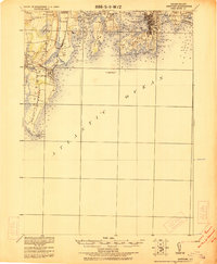
The coastal defenses of Narragansett Bay are prominently detailed in this early 20th-century survey, which identifies Fort Adams alongside other strategic installations like Fort Wetherill and the Naval Torpedo Sta. Goat Island. The landscape is a complex network of coastal necks and islands, including Conanicut Island and Point Judith Neck, where maritime safety is managed through several landmarks such as Beaver Tail Light and the offshore Brentons Reef Light Ship. Transportation is defined by a mix of marine ferries and the Sea View R.R. Co. Electric line, which served growing seaside communities like Narragansett Pier. Inland, the map captures established settlements such as Peacedale and Wakefield, showing the area's transition from agricultural hills like Rose Hill to the busy port activity in Newport.
Find a feature on this map
81 named features on this map. Tap any name to fly to it.
Don’t see what you’re looking for? This feature index may not catch every label — zoom into the map to look around manually.
Map Details
Editions of this 1922 Newport Map
This is the sole edition of this map. No revisions or reprints were ever made.
Other maps of this area

1885 · Sakonnet
USGS Topo · 1:62,500

1888 · Fall River
USGS Topo · 1:62,500

1888 · Sakonnet
USGS Topo · 1:62,500

1889 · Charlestown
USGS Topo · 1:62,500

1889 · Newport
USGS Topo · 1:62,500

1889 · Block Island
USGS Topo · 1:62,500

1890 · Narragansett Bay
USGS Topo · 1:62,500

1890 · Kent
USGS Topo · 1:62,500

1892 · Narragansett Bay
USGS Topo · 1:62,500

1893 · Sakonnet
USGS Topo · 1:62,500