1935 Map of Newport
USGS Topo · Published 1935About this map
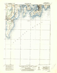
Coastal defenses and maritime infrastructure dominate this mid-1930s depiction of the Rhode Island shoreline. The landscape is defined by the strategic military presence at Fort Adams, Fort Wetherill, and Fort Getty, reflecting the area's importance for Narragansett Bay's naval security. The intricate coastline is meticulously detailed with sounding depths and navigational aids, including the Brentons Reef Light Ship and the Beaver Tail Light on the southern tip of Conanicut Island.
Find a feature on this map
72 named features on this map. Tap any name to fly to it.
Don’t see what you’re looking for? This feature index may not catch every label — zoom into the map to look around manually.
Map Details
Editions of this 1935 Newport Map
This is the sole edition of this map. No revisions or reprints were ever made.
Other maps of this area

1885 · Sakonnet
USGS Topo · 1:62,500

1888 · Fall River
USGS Topo · 1:62,500

1888 · Sakonnet
USGS Topo · 1:62,500

1889 · Charlestown
USGS Topo · 1:62,500

1889 · Newport
USGS Topo · 1:62,500

1889 · Block Island
USGS Topo · 1:62,500

1890 · Narragansett Bay
USGS Topo · 1:62,500

1890 · Kent
USGS Topo · 1:62,500

1892 · Narragansett Bay
USGS Topo · 1:62,500

1893 · Sakonnet
USGS Topo · 1:62,500