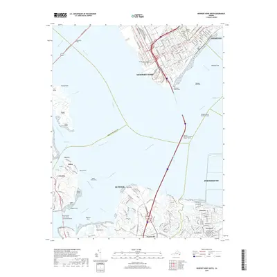
2019 Map of Newport News South
USGS Topo · Published 2019About this map
The James River dominates this coastal landscape, serving as the central artery between Newport News and the surrounding shores of Suffolk and Hampton. The map details the complex maritime infrastructure of the Hampton Roads region, anchored by the Monitor - Merrimac Memorial Bridge - Tunnel and the James River Bridge. These massive spans connect the urban core with residential communities and former agricultural land. On the western bank, small settlements such as Eclipse and Crittenden are situated near Batten Bay and the winding Chuckatuck Creek. Inland, local history is preserved through family and community landmarks like Ames Cem, Wright Cem, and Benns Church. The transition from the developed waterfront at Newport News Point to the wetlands and marshes of Ragged Island illustrates the geographic variety of the Virginia Tidewater. Subdivisions like Twin Pines and Merrifield show the continued growth of the region into the late 2010s.
Find a feature on this map
175 named features on this map. Tap any name to fly to it.
Don’t see what you’re looking for? This feature index may not catch every label — zoom into the map to look around manually.
Map Details
Editions of this 2019 Newport News South Map
This is the sole edition of this map. No revisions or reprints were ever made.
Other maps of this area

1907 · Norfolk
USGS Topo · 1:125,000

1907 · Yorktown
USGS Topo · 1:62,500

1907 · Hampton
USGS Topo · 1:62,500

1919 · Smithfield
USGS Topo · 1:62,500

1921 · Newport News
USGS Topo · 1:62,500

1943 · Yorktown
USGS Topo · 1:62,500

1943 · Richmond
USGS Topo · 1:250,000

1944 · Hampton
USGS Topo · 1:24,000

1944 · Morrison
USGS Topo · 1:24,000

1944 · Norfolk South
USGS Topo · 1:25,000