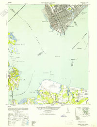
1952 Map of Newport News
USGS Topo · Published 1952About this map
The industrial and maritime activity of the James River and Hampton Roads waterfront dominates this mid-century survey, revealing the complex infrastructure of Newport News and its neighboring shores. The bustling urban grid includes the C & O rail yards, the Small Boat Harbor, and the extensive grounds of Camp Stuart and the Virginia School Deaf and Blind. Across the water, the landscape shifts to the military and defensive installations of the Nansemond Ordnance Depot and the US Naval Reservation on Craney Island. Along the western shore of the Nansemond River, the fishing and oyster-working settlements of Eclipse and Crittenden are visible. The map records a critical era of coastal defense and transportation, featuring the original James River Bridge (Toll) and the Atlantic Coast Line railroad moving goods through Sleepy Hole and Huntersville.
Find a feature on this map
54 named features on this map. Tap any name to fly to it.
Don’t see what you’re looking for? This feature index may not catch every label — zoom into the map to look around manually.
Map Details
Editions of this 1952 Newport News Map
This is the sole edition of this map. No revisions or reprints were ever made.
Other maps of this area

1907 · Norfolk
USGS Topo · 1:125,000

1907 · Yorktown
USGS Topo · 1:62,500

1907 · Hampton
USGS Topo · 1:62,500

1919 · Smithfield
USGS Topo · 1:62,500

1921 · Newport News
USGS Topo · 1:62,500

1943 · Yorktown
USGS Topo · 1:62,500

1943 · Richmond
USGS Topo · 1:250,000

1944 · Hampton
USGS Topo · 1:24,000

1944 · Morrison
USGS Topo · 1:24,000

1944 · Norfolk South
USGS Topo · 1:25,000