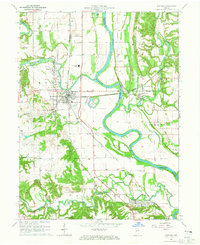
1964 Map of Newport
USGS Topo · Published 1965About this map
The Wabash River forms the central spine of this mid-century Indiana survey, where the confluence with the Vermilion River and Little Vermilion River shaped the early infrastructure of Vermillion and Fountain Counties. The landscape is defined by its deep commitment to community institutions, notably the Collett Orphanage and schools like the North Vermillion High Sch and Township Sch. Settlement patterns cluster around river crossings and rail lines, with Eugene and Cayuga serving as primary hubs. Local genealogy is well-preserved through numerous family burial sites, including Groenendyke Cem, Isle Cem, and Silver Island Cem. The inclusion of a Covered Bridge near Eugene and the Waterman Ch reflects the persistence of nineteenth-century landmarks within a 1960s landscape still serviced by the Chicago and Eastern Illinois and Chicago and St Louis railroads.
Find a feature on this map
44 named features on this map. Tap any name to fly to it.
Don’t see what you’re looking for? This feature index may not catch every label — zoom into the map to look around manually.
Map Details
Editions of this 1964 Newport Map
2 editions found
Other maps of this area

1899 · Danville
USGS Topo · 1:62,500

1900 · Danville
USGS Topo · 1:62,500

1947 · Ridge Farm
USGS Topo · 1:62,500

1950 · Danville SE
USGS Topo · 1:24,000

1951 · Danville SE
USGS Topo · 1:24,000

1953 · Danville
USGS Topo · 1:250,000

1953 · Indianapolis
USGS Topo · 1:250,000

1955 · Danville
USGS Topo · 1:250,000

1955 · Kingman
USGS Topo · 1:24,000

1955 · Humrick
USGS Topo · 1:24,000