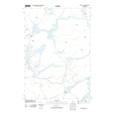
2010 Map of Newton Falls
USGS Topo · Published 2010About this map
Newton Falls and Wanakena anchor this landscape within the Adirondack Park, where the winding Oswegatchie River and its various outlets dictate the local geography. The map reveals a region defined by its water and woods, featuring substantial bodies like Chaumont Pond and the extensive Dead Creek Flow. Local infrastructure, including Ranger School Rd and Benson Mines-Newton Falls Rd, provides access to the interior terrain marked by prominent heights such as Spruce Mountain and Rocky Mountain. The shoreline of the southern flowage is punctuated by named points like Lansings Point and Flatiron Point, indicating the importance of these waterways for navigation or recreation. Smaller, secluded water bodies like Nicks Pond and Sunny Pond are tucked away from the main river channels, illustrating the dense hydrological network of the Fine region during this 2010 survey.
Find a feature on this map
38 named features on this map. Tap any name to fly to it.
Don’t see what you’re looking for? This feature index may not catch every label — zoom into the map to look around manually.
Map Details
Editions of this 2010 Newton Falls Map
This is the sole edition of this map. No revisions or reprints were ever made.
Other maps of this area

1915 · Russell
USGS Topo · 1:62,500

1916 · Oswegatchie
USGS Topo · 1:62,500

1918 · Russell
USGS Topo · 1:62,500

1918 · Oswegatchie
USGS Topo · 1:62,500

1919 · Cranberry Lake
USGS Topo · 1:62,500

1921 · Cranberry Lake
USGS Topo · 1:62,500

1921 · Stark
USGS Topo · 1:62,500

1923 · Stark
USGS Topo · 1:62,500

1931 · Cranberry Lake
USGS Topo · 1:62,500

1940 · Stark
USGS Topo · 1:62,500