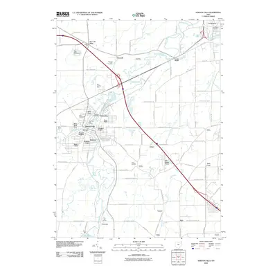
2010 Map of Newton Falls
USGS Topo · Published 2010About this map
Newton Falls serves as the focal point of this 2010 survey, situated at the confluence of the West Branch Mahoning River and the East Branch Mahoning River. The map captures a mix of residential neighborhoods like Arlington Heights and Maderite Heights alongside industrial and transportation corridors. Of particular interest to local historians is the Newton Falls Covered Bridge and the Newton Falls Dam, landmarks that define the town's character on the water. To the north, the landscape shifts toward the community of Braceville and the Riverview Golf Course, while the southern reaches are dominated by the northern tip of Lake Milton and the Milton Dam. Numerous family and religious burial grounds, including Saint Michaels Cemetery and the Duck Creek Cemetery, are documented across the rural stretches between settlements such as Pricetown and Center World.
Find a feature on this map
91 named features on this map. Tap any name to fly to it.
Don’t see what you’re looking for? This feature index may not catch every label — zoom into the map to look around manually.
Map Details
Editions of this 2010 Newton Falls Map
This is the sole edition of this map. No revisions or reprints were ever made.
Other maps of this area

1905 · Bristolville
USGS Topo · 1:62,500

1905 · Garrettsville
USGS Topo · 1:62,500

1906 · Ravenna
USGS Topo · 1:62,500

1907 · Bristolville
USGS Topo · 1:62,500

1907 · Garrettsville
USGS Topo · 1:62,500

1908 · Warren
USGS Topo · 1:62,500

1908 · Ravenna
USGS Topo · 1:62,500

1950 · Cleveland
USGS Topo · 1:250,000

1952 · Lake Milton
USGS Topo · 1:24,000

1952 · Canfield
USGS Topo · 1:24,000