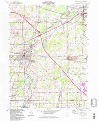
1994 Map of Newton Falls
USGS Topo · Published 1997About this map
The Mahoning River winds through this corner of Trumbull and Mahoning Counties, anchoring a landscape shaped by heavy industry and military logistics. The eastern edge of the U S Military Reservation Ravenna Arsenal occupies the western portion of the map, while the town of Newton Falls sits at the confluence of the river's West Branch. This era reflects the established infrastructure of the Ohio Turnpike and Conrail rail lines that intersect near Braceville, facilitating movement across the region. Local history is preserved in sites like the St Michaels Cem and the Wilderson Cem, while the industrial character of the area is highlighted by a large Slag Pile and multiple quarries near Baileys Corners. To the south, the map reaches the northern waters of Milton, showing the Lake Milton Spillway and the lakeside community of Craig Beach.
Find a feature on this map
57 named features on this map. Tap any name to fly to it.
Don’t see what you’re looking for? This feature index may not catch every label — zoom into the map to look around manually.
Map Details
Editions of this 1994 Newton Falls Map
This is the sole edition of this map. No revisions or reprints were ever made.
Other maps of this area

1905 · Bristolville
USGS Topo · 1:62,500

1905 · Garrettsville
USGS Topo · 1:62,500

1906 · Ravenna
USGS Topo · 1:62,500

1907 · Bristolville
USGS Topo · 1:62,500

1907 · Garrettsville
USGS Topo · 1:62,500

1908 · Warren
USGS Topo · 1:62,500

1908 · Ravenna
USGS Topo · 1:62,500

1950 · Cleveland
USGS Topo · 1:250,000

1952 · Lake Milton
USGS Topo · 1:24,000

1952 · Canfield
USGS Topo · 1:24,000