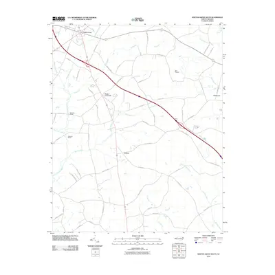
2010 Map of Newton Grove South
USGS Topo · Published 2010About this map
Newton Grove anchors the northern edge of this coastal plain landscape, where a dense network of blackwater drainages dictates the layout of local roads and farmsteads. The terrain is defined by sprawling wetlands and low-lying woods, including Bull Pocosin and the expansive Goshen Swamp. These water systems converge toward Great Coharie Creek and Six Runs Creek, with historic crossings such as Barksdale Bridge and Dameron Bridge providing essential connectivity.
Find a feature on this map
57 named features on this map. Tap any name to fly to it.
Don’t see what you’re looking for? This feature index may not catch every label — zoom into the map to look around manually.
Map Details
Editions of this 2010 Newton Grove South Map
This is the sole edition of this map. No revisions or reprints were ever made.
Other maps of this area

1906 · Four Oaks
USGS Topo · 1:48,000

1908 · Four Oaks
USGS Topo · 1:62,500

1909 · Coharie
USGS Topo · 1:62,500

1953 · Raleigh
USGS Topo · 1:250,000

1954 · Raleigh
USGS Topo · 1:250,000

1974 · Grantham
USGS Topo · 1:24,000

1975 · Faison
USGS Topo · 1:24,000
1978 · Dobbersville
USGS Topo · 1:24,000
1986 · Peacocks Crossroads
USGS Topo · 1:24,000
1986 · Timothy
USGS Topo · 1:24,000