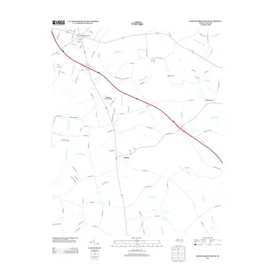
2013 Map of Newton Grove South
USGS Topo · Published 2013About this map
Newton Grove serves as the northern anchor for this landscape, where the street grid of N Church St and Sunset St transitions quickly into a network of rural roads and extensive wetlands. The region is defined by its complex drainage patterns, with Beaverdam Swamp, Kill Swamp, and Craddock Swamp threading through the countryside. These low-lying areas surround higher ground occupied by local settlements like Monks Crossroads and Hobbton. A unique ecological feature, the Bull Pocosin, highlights the specific coastal plain terrain of Sampson County. Interstate 40 cuts a modern path across these traditional wetlands, while older crossing points like Barksdale Bridge and Dameron Bridge over the Great Coharie Cr mark the historic routes connecting isolated farmsteads and the community of Suttentown in the east.
Find a feature on this map
101 named features on this map. Tap any name to fly to it.
Don’t see what you’re looking for? This feature index may not catch every label — zoom into the map to look around manually.
Map Details
Editions of this 2013 Newton Grove South Map
This is the sole edition of this map. No revisions or reprints were ever made.
Other maps of this area

1906 · Four Oaks
USGS Topo · 1:48,000

1908 · Four Oaks
USGS Topo · 1:62,500

1909 · Coharie
USGS Topo · 1:62,500

1953 · Raleigh
USGS Topo · 1:250,000

1954 · Raleigh
USGS Topo · 1:250,000

1974 · Grantham
USGS Topo · 1:24,000

1975 · Faison
USGS Topo · 1:24,000
1978 · Dobbersville
USGS Topo · 1:24,000
1986 · Peacocks Crossroads
USGS Topo · 1:24,000
1986 · Timothy
USGS Topo · 1:24,000