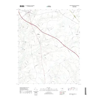
2019 Map of Newton Grove South
USGS Topo · Published 2019About this map
Newton Grove serves as the focal point of this Eastern North Carolina landscape, where a distinct radial street pattern—including Raleigh St, Goldsboro St, and Fayetteville St—diverges from the town center. The surrounding countryside in Sampson and Wayne Counties is defined by an extensive network of wetlands and slow-moving water, most notably the broad Bull Pocosin and the winding reaches of Six Runs Cr and Goshen Swamp.
Find a feature on this map
90 named features on this map. Tap any name to fly to it.
Don’t see what you’re looking for? This feature index may not catch every label — zoom into the map to look around manually.
Map Details
Editions of this 2019 Newton Grove South Map
This is the sole edition of this map. No revisions or reprints were ever made.
Other maps of this area

1906 · Four Oaks
USGS Topo · 1:48,000

1908 · Four Oaks
USGS Topo · 1:62,500

1909 · Coharie
USGS Topo · 1:62,500

1953 · Raleigh
USGS Topo · 1:250,000

1954 · Raleigh
USGS Topo · 1:250,000

1974 · Grantham
USGS Topo · 1:24,000

1975 · Faison
USGS Topo · 1:24,000
1978 · Dobbersville
USGS Topo · 1:24,000
1986 · Peacocks Crossroads
USGS Topo · 1:24,000
1986 · Timothy
USGS Topo · 1:24,000