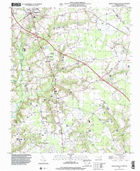
1997 Map of Newton Grove South
USGS Topo · Published 2000About this map
Newton Grove serves as the focal point of this late-twentieth-century landscape, where major regional corridors intersect in the northern portion of Sampson County. The terrain is defined by an intricate network of wetlands, including Great Coharie Creek and the winding Goshen Swamp, which likely shaped early settlement patterns and road placements. This geography is dotted with community landmarks that provide significant value for local historians, notably a high density of rural houses of worship such as Pleasant Union Ch and St Matthew Ch.
Find a feature on this map
32 named features on this map. Tap any name to fly to it.
Don’t see what you’re looking for? This feature index may not catch every label — zoom into the map to look around manually.
Map Details
Editions of this 1997 Newton Grove South Map
This is the sole edition of this map. No revisions or reprints were ever made.
Other maps of this area

1906 · Four Oaks
USGS Topo · 1:48,000

1908 · Four Oaks
USGS Topo · 1:62,500

1909 · Coharie
USGS Topo · 1:62,500

1953 · Raleigh
USGS Topo · 1:250,000

1954 · Raleigh
USGS Topo · 1:250,000

1974 · Grantham
USGS Topo · 1:24,000

1975 · Faison
USGS Topo · 1:24,000
1978 · Dobbersville
USGS Topo · 1:24,000
1986 · Peacocks Crossroads
USGS Topo · 1:24,000
1986 · Timothy
USGS Topo · 1:24,000