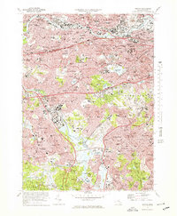
1970 Map of Newton
USGS Topo · Published 1978About this map
The Charles River forms the geographic heart of this suburban landscape, winding past established neighborhoods like Newton Lower Falls and Waltham. By the 1970s, the region's dense development is evident in the complex networks of the Massachusetts Turnpike and the Penn Central railroad, which serve as primary transit corridors through Newtonville and Brighton. This survey documents a transition in local infrastructure, showing the M B T A lines alongside traditional settlements such as Auburndale and Nonantum.
Find a feature on this map
116 named features on this map. Tap any name to fly to it.
Don’t see what you’re looking for? This feature index may not catch every label — zoom into the map to look around manually.
Map Details
Editions of this 1970 Newton Map
2 editions found
Other maps of this area

1886 · Dedham
USGS Topo · 1:62,500

1886 · Framingham
USGS Topo · 1:62,500

1887 · Franklin
USGS Topo · 1:62,500

1889 · Franklin
USGS Topo · 1:62,500

1889 · Framingham
USGS Topo · 1:62,500

1893 · Franklin
USGS Topo · 1:62,500

1893 · Boston
USGS Topo · 1:62,500

1894 · Dedham
USGS Topo · 1:62,500

1894 · Framingham
USGS Topo · 1:62,500

1903 · Boston
USGS Topo · 1:62,500