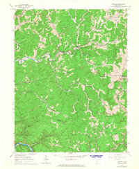
1966 Map of Newton
USGS Topo · Published 1968About this map
The Big Sandy River and its labyrinthine drainage system define the landscape of this mid-1960s survey along the Roane and Clay county lines. At the intersection of Big Sandy Creek and Dog Creek, the settlement of Newton serves as a local hub, while smaller communities like Left Hand and Uler occupy the narrow valley floors. The map reveals an intensive extractive economy, with hundreds of labels for Gas Wells and Oil Wells peppered across the steep ridges and hollows, including names like Bloontimber Run and Granny Creek. Transportation follows the water, with the Baltimore and Ohio railroad skirting the Elk River in the southwestern corner near Paxton. This document is particularly valuable for genealogists, as it preserves the locations of numerous family-linked sites such as Smith Cem, Laurel Point Cem, and rural congregations like Rogersfork Ch and Goodwin Ch.
Find a feature on this map
60 named features on this map. Tap any name to fly to it.
Don’t see what you’re looking for? This feature index may not catch every label — zoom into the map to look around manually.
Map Details
Editions of this 1966 Newton Map
2 editions found
Other maps of this area

1897 · Kanawha Falls
USGS Topo · 1:125,000

1900 · Kanawha Falls
USGS Topo · 1:125,000

1901 · Kanawha Falls
USGS Topo · 1:125,000

1906 · Otter
USGS Topo · 1:62,500

1906 · Walton
USGS Topo · 1:62,500

1907 · Otter
USGS Topo · 1:62,500

1907 · Walton
USGS Topo · 1:62,500

1907 · Clendenin
USGS Topo · 1:62,500

1908 · Clay
USGS Topo · 1:48,000

1909 · Clendenin
USGS Topo · 1:62,500