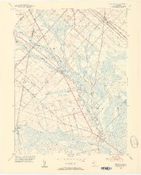
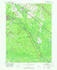
1953 Map of Newtonville
USGS Topo · Published 1954About this map
The Great Egg Harbor River carves a winding path through the heart of the New Jersey Pine Barrens, dictating the settlement patterns and industry of the early 1950s. This survey illustrates the convergence of major regional arteries, including the White Horse Pike and Black Horse Pike, which intersect near the community of Folsom. The landscape is defined by its agricultural and natural resources, evidenced by multiple Cranberry Bogs and Gravel Pits scattered across the sandy terrain. Small communities like Newtonville and Weymouth are anchored by local landmarks such as Bethlehem Ch and Mt Zion Ch. The Pennsylvania-Reading Seashore Lines provides a heavy rail connection through Da Costa, linking this rural interior to the coastal and urban centers. Further south, the map reveals the lower reaches of Deep Run and Little Mill Run, where the river network broadens into the wetlands characteristic of Atlantic County.
Find a feature on this map
46 named features on this map. Tap any name to fly to it.
Don’t see what you’re looking for? This feature index may not catch every label — zoom into the map to look around manually.
Map Details
Editions of this 1953 Newtonville Map
5 editions found
Other maps of this area

1890 · Great Egg Harbor
USGS Topo · 1:62,500

1890 · Hammonton
USGS Topo · 1:62,500

1890 · Tuckahoe
USGS Topo · 1:62,500

1890 · Mullica
USGS Topo · 1:62,500

1893 · Great Egg Harbor
USGS Topo · 1:62,500

1893 · Tuckahoe
USGS Topo · 1:62,500

1894 · Hammonton
USGS Topo · 1:62,500

1894 · Mullica
USGS Topo · 1:62,500

1898 · Mullica
USGS Topo · 1:62,500

1898 · Hammonton
USGS Topo · 1:62,500