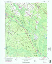
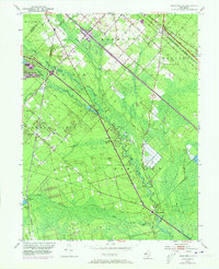
1953 Map of Newtonville
USGS Topo · Published 1973About this map
The Great Egg Harbor River meanders through this portion of the New Jersey Pine Barrens, defining the landscape around the settlements of Folsom, Newtonville, and Penny Pot. This 1953 survey, updated with 1972 revisions, illustrates the agricultural and transit patterns of Atlantic County, featuring numerous Cranberry Bog operations and extensive Gravel Pits that supported local industry. Religious and social centers like St James Ch, Bethlehem Ch, and Mt Zion Ch are clearly marked, alongside the Newtonville Cem, providing valuable data for genealogical research. The transit network is dominated by the Pennsylvania-Reading Seashore Lines and the emerging path of the Atlantic City Expressway, which intersects the older Black Horse Pike. Toward the southeast, the historic area of Weymouth sits near the Little Mill River, where the terrain transitions toward the coastal wetlands.
Find a feature on this map
35 named features on this map. Tap any name to fly to it.
Don’t see what you’re looking for? This feature index may not catch every label — zoom into the map to look around manually.
Map Details
Editions of this 1953 Newtonville Map
5 editions found
Other maps of this area

1890 · Great Egg Harbor
USGS Topo · 1:62,500

1890 · Hammonton
USGS Topo · 1:62,500

1890 · Tuckahoe
USGS Topo · 1:62,500

1890 · Mullica
USGS Topo · 1:62,500

1893 · Great Egg Harbor
USGS Topo · 1:62,500

1893 · Tuckahoe
USGS Topo · 1:62,500

1894 · Hammonton
USGS Topo · 1:62,500

1894 · Mullica
USGS Topo · 1:62,500

1898 · Mullica
USGS Topo · 1:62,500

1898 · Hammonton
USGS Topo · 1:62,500