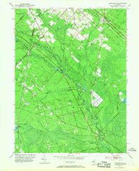
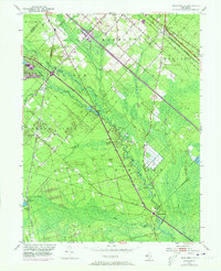
1953 Map of Newtonville
USGS Topo · Published 1968About this map
Great Egg Harbor River meanders through the Pine Barrens of Atlantic County, defining the agricultural and industrial character of the region in the early 1950s. The landscape is marked by the distinct geometry of several Cranberry Bogs and gravel extraction sites, while the Pennsylvania-Reading Seashore Lines provides a heavy rail connection through the northeast corner at Da Costa. Small community hubs like Newtonville and Folsom are characterized by their local institutions, including Bethlehem Ch and the Newtonville Cem. The map reveals a transition from the structured street grids of Hammonton in the north to more isolated settlements like Pancoast and Weymouth further south. Notable water features like Makepeace Lake and Cushman Lake anchor the eastern and western edges, while the Black Horse Pike serves as a primary transit artery across the low-lying terrain.
Find a feature on this map
43 named features on this map. Tap any name to fly to it.
Don’t see what you’re looking for? This feature index may not catch every label — zoom into the map to look around manually.
Map Details
Editions of this 1953 Newtonville Map
5 editions found
Other maps of this area

1890 · Great Egg Harbor
USGS Topo · 1:62,500

1890 · Hammonton
USGS Topo · 1:62,500

1890 · Tuckahoe
USGS Topo · 1:62,500

1890 · Mullica
USGS Topo · 1:62,500

1893 · Great Egg Harbor
USGS Topo · 1:62,500

1893 · Tuckahoe
USGS Topo · 1:62,500

1894 · Hammonton
USGS Topo · 1:62,500

1894 · Mullica
USGS Topo · 1:62,500

1898 · Mullica
USGS Topo · 1:62,500

1898 · Hammonton
USGS Topo · 1:62,500