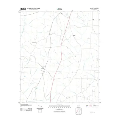
2011 Map of Newville
USGS Topo · Published 2011About this map
Newville serves as the primary hub of this Henry County landscape, where the local road network converges near Newville Cemetery. The area is defined by a dense system of watercourses, including Hodges Mathis Mill Creek and Spivey Mill Creek, which speak to the historic water-powered industry of the region. Scattered settlements like Capps, Danzey, and Tumbleton are connected by a grid of county roads, with agricultural life evidenced by features such as Clemmons Gin Branch and several family-named landmarks. Genealogists will find a high concentration of burial sites throughout the quadrangle, from Union Springs Cemetery in the west to Zion Cemetery in the east, providing a clear record of the area's established families and community centers.
Find a feature on this map
79 named features on this map. Tap any name to fly to it.
Don’t see what you’re looking for? This feature index may not catch every label — zoom into the map to look around manually.
Map Details
Editions of this 2011 Newville Map
This is the sole edition of this map. No revisions or reprints were ever made.
Other maps of this area

1953 · Dothan
USGS Topo · 1:250,000

1954 · Dothan
USGS Topo · 1:250,000

1955 · Dothan
USGS Topo · 1:250,000

1969 · Abbeville West
USGS Topo · 1:24,000
1969 · Midland City
USGS Topo · 1:24,000
1969 · Clopton
USGS Topo · 1:24,000

1969 · Headland
USGS Topo · 1:24,000

1969 · Abbeville East
USGS Topo · 1:24,000
1969 · Echo
USGS Topo · 1:24,000

1969 · Newville
USGS Topo · 1:24,000