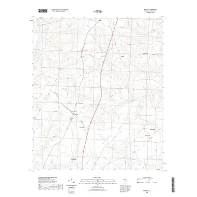
2020 Map of Newville
USGS Topo · Published 2020About this map
Newville and the northern reaches of Headland anchor this part of Henry County, where the landscape is defined by the headwaters of several critical Gulf-bound drainage systems. The terrain transitions between the East Fork Choctawhatchee River and the West Fork Choctawhatchee River, with numerous small tributaries like Hodges Mathis Mill Cr and Spivey Mill Cr carving the landscape. For local historians, the distribution of rural cemeteries such as Union Springs Cem and Oaky Grove Cem provides a map of early family settlement patterns across the townships. Smaller crossroads communities like Tumbleton and Capps show the enduring nature of these agricultural hubs, while the proximity of Griffin Pond and Lake Mila highlights the localized water features that served the region's farms and homesteads.
Find a feature on this map
88 named features on this map. Tap any name to fly to it.
Don’t see what you’re looking for? This feature index may not catch every label — zoom into the map to look around manually.
Map Details
Editions of this 2020 Newville Map
This is the sole edition of this map. No revisions or reprints were ever made.
Other maps of this area

1953 · Dothan
USGS Topo · 1:250,000

1954 · Dothan
USGS Topo · 1:250,000

1955 · Dothan
USGS Topo · 1:250,000

1969 · Abbeville West
USGS Topo · 1:24,000
1969 · Midland City
USGS Topo · 1:24,000
1969 · Clopton
USGS Topo · 1:24,000

1969 · Headland
USGS Topo · 1:24,000

1969 · Abbeville East
USGS Topo · 1:24,000
1969 · Echo
USGS Topo · 1:24,000

1969 · Newville
USGS Topo · 1:24,000