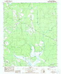
1988 Map of Neyles
USGS Topo · Published 1988About this map
Ashepoo River meanders through this Lowcountry landscape in the late 1980s, anchoring a region defined by its complex drainage network and small rural settlements. The map shows the small community of Neyles positioned near the headwaters of Chessey Creek, while Ritter and Ashepoo Crossing sit further west and south, marking historic points of transit near the wetlands. The terrain is dominated by water, from the broad Tupelo Swamp to smaller tributaries like Baptist Church Branch and Pringle Creek.
Find a feature on this map
13 named features on this map. Tap any name to fly to it.
Don’t see what you’re looking for? This feature index may not catch every label — zoom into the map to look around manually.
Map Details
Editions of this 1988 Neyles Map
This is the sole edition of this map. No revisions or reprints were ever made.
Other maps of this area

1918 · Walterboro
USGS Topo · 1:62,500

1918 · Green Pond
USGS Topo · 1:62,500

1918 · Cottageville
USGS Topo · 1:62,500

1919 · Edisto Island
USGS Topo · 1:62,500

1943 · Cottageville
USGS Topo · 1:62,500

1943 · Edisto Island
USGS Topo · 1:62,500

1943 · Green Pond
USGS Topo · 1:62,500

1943 · Walterboro
USGS Topo · 1:62,500

1947 · Savannah
USGS Topo · 1:250,000

1948 · Savannah
USGS Topo · 1:250,000