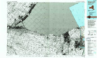
1986 Map of Niagara Falls
USGS Topo · Published 1994About this map
The Niagara River defines this international border landscape, shown here as it transitioned into the mid-1980s. The map illustrates the heavy concentration of industrial and power infrastructure that historically supported the region, including the massive reservoir, powerplant, and multiple substations that dominate the terrain near Lewiston. This era of development is contrasted by the preserved grounds of Fort Niagara State Park and the Niagara Reservation, which protect the area's natural landmarks and early colonial history. North of the city, residential growth is evident in communities like Youngstown Estates and Collingwood Estates. Traces of the region's earlier transportation network remain visible through the Old RR Grade, while modern transit is represented by the Niagara Scenic Pkwy following the river's edge toward Lake Ontario.
Find a feature on this map
27 named features on this map. Tap any name to fly to it.
Don’t see what you’re looking for? This feature index may not catch every label — zoom into the map to look around manually.
Map Details
Editions of this 1986 Niagara Falls Map
2 editions found
Other maps of this area

1894 · Buffalo
USGS Topo · 1:62,500

1894 · Niagara Falls
USGS Topo · 1:62,500

1894 · Wilson
USGS Topo · 1:62,500

1896 · Niagara Falls
USGS Topo · 1:62,500

1897 · Tonawanda
USGS Topo · 1:62,500

1899 · Niagara
USGS Topo · 1:125,000

1900 · Wilson
USGS Topo · 1:62,500

1900 · Tonawanda
USGS Topo · 1:62,500

1900 · Niagara Falls
USGS Topo · 1:62,500

1901 · Buffalo
USGS Topo · 1:62,500