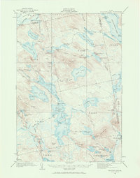
1932 Map of Nicatous Lake
USGS Topo · Published 1970About this map
1000 Acre Heath and a complex network of glacial lakes dominate this interior Maine landscape at the transition between the early logging era and the rise of sporting camps. The northern reaches of Hancock County are marked by remote outposts such as Poplar Tavern Camp and the Nicatous Club, reflecting the region's historical importance for timber and wilderness recreation. The drainage systems are highly articulated, with the Passadumkeag River flowing northwest while the sprawling Duck Lake and Sysladobsis Lake occupy the central and eastern basins. Small encampments like No 6 Camp and No 2 Camp appear along the lake shores, connected by established water routes and simple trails. The presence of Knight Dam at the outlet of the Fifth Lake stream suggests early water level management for log driving or early local power.
Find a feature on this map
101 named features on this map. Tap any name to fly to it.
Don’t see what you’re looking for? This feature index may not catch every label — zoom into the map to look around manually.
Map Details
Editions of this 1932 Nicatous Lake Map
4 editions found
Other maps of this area

1920 · Winn
USGS Topo · 1:62,500

1929 · Great Pond
USGS Topo · 1:48,000

1929 · Lead Mountain
USGS Topo · 1:48,000

1931 · Springfield
USGS Topo · 1:48,000

1931 · Saponac
USGS Topo · 1:48,000

1932 · Nicatous Lake
USGS Topo · 1:48,000

1932 · Lead Mountain
USGS Topo · 1:62,500

1932 · Great Pond
USGS Topo · 1:62,500

1934 · Saponac
USGS Topo · 1:62,500

1934 · Nicatous Lake
USGS Topo · 1:62,500