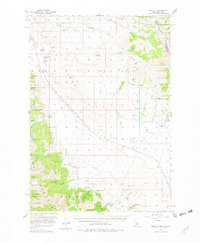
1956 Map of Nicholia
USGS Topo · Published 1982About this map
The Continental Divide snake along the high peaks of the Beaverhead Mountains, defining the boundary between Idaho and Montana in this high-altitude landscape. Within Birch Creek Valley, the map captures a period of transition where the infrastructure of early industry remains visible alongside active ranching. Evidence of late 19th-century mining and smelting is preserved at the Hahn (Site) and the settlement of Nicholia, where a Cem and nearby Kilns point to the area's history as a lead and silver producer. The Old R R Grade traces a path through the valley, marking the former route of the narrow-gauge Gilmour and Pittsburgh Railroad. This transport network once connected the remote canyon operations, such as those in Coal Kiln Canyon and Ramsey Canyon, to broader markets before the line was salvaged. Water management is central to the valley floor, indicated by a prominent Ditch and numerous named springs like McCoy Sprs and Slaughterhouse Spring.
Find a feature on this map
73 named features on this map. Tap any name to fly to it.
Don’t see what you’re looking for? This feature index may not catch every label — zoom into the map to look around manually.
Map Details
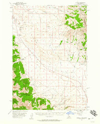
Editions of this 1956 Nicholia Map
3 editions found
Other maps of this area

1955 · Dubois
USGS Topo · 1:250,000

1956 · Leadore
USGS Topo · 1:62,500

1956 · Morrison Lake
USGS Topo · 1:62,500

1956 · Nicholia
USGS Topo · 1:62,500

1957 · Diamond Peak
USGS Topo · 1:62,500

1957 · Gilmore
USGS Topo · 1:62,500

1957 · Scott Peak
USGS Topo · 1:62,500

1957 · Hawley Mountain
USGS Topo · 1:62,500

1958 · Dubois
USGS Topo · 1:250,000

1965 · Island Butte
USGS Topo · 1:24,000