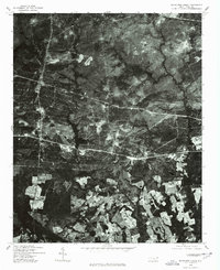
1976 Map of Nicholson Creek
USGS Topo · Published 1978About this map
Wayside and the surrounding rural landscapes of Hoke County are captured in this 1976 orthophotoquad, which uses rectified aerial imagery to show the physical reality of the terrain. The dark, sprawling waters of Mott Lake dominate the central portion of the sheet, providing a stark contrast to the dense vegetation and carved drainage patterns of Nicholson Creek. Unlike traditional topographic maps, this imagery reveals the exact footprint of forest clearings, agricultural fields, and the network of unpaved roads and firebreaks that crisscrossed the area during the mid-1970s. The settlement at Wayside appears as a small cluster of structures amidst a patchwork of managed timberland and farms, illustrating the rural character of this North Carolina region before later decades of development and land use changes.
Find a feature on this map
3 named features on this map. Tap any name to fly to it.
Don’t see what you’re looking for? This feature index may not catch every label — zoom into the map to look around manually.
Map Details
Editions of this 1976 Nicholson Creek Map
This is the sole edition of this map. No revisions or reprints were ever made.
Other maps of this area

1948 · Southern Pines
USGS Topo · 1:62,500

1948 · Clifdale
USGS Topo · 1:62,500

1948 · Nicholson Creek
USGS Topo · 1:24,000

1948 · Clifdale
USGS Topo · 1:24,000

1948 · Mc Cain
USGS Topo · 1:24,000

1949 · Wagram
USGS Topo · 1:24,000

1949 · Laurinburg
USGS Topo · 1:62,500

1950 · Clifdale
USGS Topo · 1:24,000

1950 · Sanatorium
USGS Topo · 1:24,000

1950 · Lobelia
USGS Topo · 1:24,000