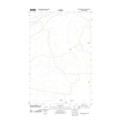
2011 Map of Nightshoot Coulee
USGS Topo · Published 2011About this map
The Milk River winds through the northern portion of this Glacier County landscape, defining the hydrology of a region marked by extensive drainage patterns. The topography is dominated by numerous coulees that carve into the high plains, including Nightshoot Coulee and Little Rock Coulee. These features represent a characteristic Montana grassland environment where water flow has historically shaped the routes of travel and land use. Isolated landmarks like Red Buttes rise above the drainage systems, providing orientation across the open terrain. Roads like Buck Ranch Rd follow the natural contours of the land, connecting remote points between Cobell Coulee and Hoodoo Coulee. This U.S. Geological Survey provides a detailed record of the physical geography near the Canadian border, showing the intersection of watercourses like Cut Bank John Coulee with the sparsely settled range.
Find a feature on this map
8 named features on this map. Tap any name to fly to it.
Don’t see what you’re looking for? This feature index may not catch every label — zoom into the map to look around manually.
Map Details
Editions of this 2011 Nightshoot Coulee Map
This is the sole edition of this map. No revisions or reprints were ever made.
Other maps of this area

1901 · Browning
USGS Topo · 1:125,000

1903 · Browning
USGS Topo · 1:125,000

1911 · Blackfoot
USGS Topo · 1:125,000

1960 · Cut Bank
USGS Topo · 1:250,000

1963 · Cut Bank
USGS Topo · 1:250,000

1964 · Cut Bank
USGS Topo · 1:250,000

1968 · Rimrock Butte
USGS Topo · 1:24,000

1968 · Hoodoo Hill
USGS Topo · 1:24,000

1968 · Browning NE
USGS Topo · 1:24,000
1968 · Emigrant Gap
USGS Topo · 1:24,000