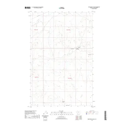
2020 Map of Nightshoot Coulee
USGS Topo · Published 2020About this map
Milk River flows through the northwest corner of this northern Montana landscape, part of a complex drainage network characterized by deep coulees. In this high plains environment, the terrain is defined by notable elevations such as the Red Buttes, providing significant landmarks in an otherwise open topography. The naming of the various drainage channels, including Nightshoot Coulee, Hoodoo Coulee, and Cobell Coulee, reflects the local vernacular and the critical importance of water movement across these semi-arid lands. Human presence is marked by the isolated path of Buck Ranch Rd, indicating the expansive scale of ranching operations in this portion of Glacier County. The map provides a clear view of the Public Land Survey System divisions, showing the junction of Townships 35 and 36 North, Ranges 10 and 11 West.
Find a feature on this map
12 named features on this map. Tap any name to fly to it.
Don’t see what you’re looking for? This feature index may not catch every label — zoom into the map to look around manually.
Map Details
Editions of this 2020 Nightshoot Coulee Map
This is the sole edition of this map. No revisions or reprints were ever made.
Other maps of this area

1901 · Browning
USGS Topo · 1:125,000

1903 · Browning
USGS Topo · 1:125,000

1911 · Blackfoot
USGS Topo · 1:125,000

1960 · Cut Bank
USGS Topo · 1:250,000

1963 · Cut Bank
USGS Topo · 1:250,000

1964 · Cut Bank
USGS Topo · 1:250,000

1968 · Rimrock Butte
USGS Topo · 1:24,000

1968 · Hoodoo Hill
USGS Topo · 1:24,000

1968 · Browning NE
USGS Topo · 1:24,000
1968 · Emigrant Gap
USGS Topo · 1:24,000