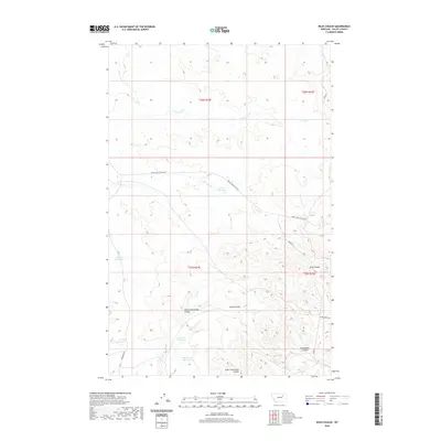
2020 Map of Niles Coulee
USGS Topo · Published 2020About this map
Niles Coulee and the surrounding drainage basins of Valley County, Montana, define this high plains landscape. The terrain is deeply etched by a network of seasonal watercourses, including North Frenchman Coulee, Frenchman Coulee, and Little Frenchman Coulee. In an environment where water management is critical for ranching and land use, numerous small catchments are distributed across the township lines of T25N and T26N. These include the Corral Reservoir, Mc Kee Reservoir, and High Moon Reservoir. Local infrastructure consists primarily of isolated access routes such as Triple Cross Access Rd and Stone House Rd, reflecting a sparse settlement pattern focused on livestock and resource management. The presence of Niles Spring and drainage from Ten Trees Cr highlights the subtle but vital riparian features that have historically dictated the placement of homesteads and corrals in this part of the Missouri River basin.
Find a feature on this map
21 named features on this map. Tap any name to fly to it.
Don’t see what you’re looking for? This feature index may not catch every label — zoom into the map to look around manually.
Map Details
Editions of this 2020 Niles Coulee Map
This is the sole edition of this map. No revisions or reprints were ever made.
Other maps of this area

1954 · Jordan
USGS Topo · 1:250,000

1954 · Glasgow
USGS Topo · 1:250,000

1956 · Jordan
USGS Topo · 1:250,000

1957 · Glasgow
USGS Topo · 1:250,000

1958 · Glasgow
USGS Topo · 1:250,000

1958 · Jordan
USGS Topo · 1:250,000

1964 · Jordan
USGS Topo · 1:250,000

1973 · Triple Crossing Reservoir West
USGS Topo · 1:24,000

1973 · Niles Coulee
USGS Topo · 1:24,000
1973 · Gibson Coulee
USGS Topo · 1:24,000