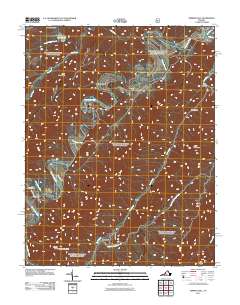
2011 Map of Nimrod Hall
USGS Topo · Published 2011About this map
The Cowpasture River anchors this central Virginia landscape, carving a serpentine path through the ridges of Rough Mountain and Little Mountain. This early 21st-century survey documents the area around the historic settlement of Nimrod Hall, where the river's winding course created narrow valleys known as drafts and hollows, such as Hickman Draft and Limekiln Hollow. Further south, the community of Copeland sits near the confluence of Pads Creek and its South Fork Pads Creek. The map details local infrastructure including the Hunt Club Dam and the Mason Tunnel, alongside small mountain outposts like Griffith and Crane. The terrain is defined by dramatic elevation changes, notably at the Rich Hole and the high Knob, reflecting the region's complex geological structure.
Find a feature on this map
26 named features on this map. Tap any name to fly to it.
Don’t see what you’re looking for? This feature index may not catch every label — zoom into the map to look around manually.
Map Details
Editions of this 2011 Nimrod Hall Map
This is the sole edition of this map. No revisions or reprints were ever made.
Other maps of this area

1894 · Natural Bridge
USGS Topo · 1:125,000

1901 · Monterey
USGS Topo · 1:125,000

1923 · Warm Springs
USGS Topo · 1:48,000

1926 · Warm Springs
USGS Topo · 1:62,500

1930 · Warm Springs Run
USGS Topo · 1:24,000

1931 · Healing Springs
USGS Topo · 1:24,000

1933 · Warm Springs Run
USGS Topo · 1:31,680

1933 · Healing Springs
USGS Topo · 1:31,680

1945 · Clifton Forge
USGS Topo · 1:62,500

1946 · Millboro
USGS Topo · 1:62,500