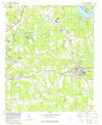
1978 Map of Ninety-Six
USGS Topo · Published 1979About this map
The Old Star Fort (Site) anchors the southeastern landscape of this late-1970s survey, marking a location of deep significance in the South Carolina backcountry. The town of Ninety Six serves as a central hub, where the Southern railway and the Seaboard Coast Line intersect, reflecting the era's transport-oriented layout. Education is a prominent theme, with the presence of Piedmont Technical College, High Sch Ninety Six, and Edgewood Middle Sch indicating the community's growth and infrastructure during this period.
Find a feature on this map
36 named features on this map. Tap any name to fly to it.
Don’t see what you’re looking for? This feature index may not catch every label — zoom into the map to look around manually.
Map Details
Editions of this 1978 Ninety-Six Map
This is the sole edition of this map. No revisions or reprints were ever made.
Other maps of this area

1892 · Abbeville
USGS Topo · 1:125,000

1908 · Kirksey
USGS Topo · 1:24,000

1941 · Spartanburg
USGS Topo · 1:250,000

1949 · Ninety-Six
USGS Topo · 1:24,000

1949 · Greenwood
USGS Topo · 1:24,000

1950 · Bradley
USGS Topo · 1:24,000

1950 · Kirksey
USGS Topo · 1:24,000

1953 · Spartanburg
USGS Topo · 1:250,000

1954 · Greenville
USGS Topo · 1:250,000

1958 · Greenville
USGS Topo · 1:250,000