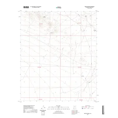
2020 Map of Ninetysix Ranch
USGS Topo · Published 2020About this map
Ninetysix Ranch serves as the primary landmark in this corner of Grant County, where the high desert landscape is defined by a network of drainage systems and isolated peaks. The Langford Mountains rise in the northwest, giving way to the sprawling Langford Draw and several seasonal water features essential for ranching in this arid climate, including Glaze Tank and Dons Tank. The drainage patterns here are distinct, with New Well Canyon and South Well Canyon carving through the terrain toward the east. A small ranching economy is evident through the naming of local landmarks like Smith Draw and the course of Ninetysix Creek. Movement through the area relies on established routes such as Separ Rd and Jones Ranch Rd, which connect these remote holdings across the township and range lines.
Find a feature on this map
20 named features on this map. Tap any name to fly to it.
Don’t see what you’re looking for? This feature index may not catch every label — zoom into the map to look around manually.
Map Details
Editions of this 2020 Ninetysix Ranch Map
This is the sole edition of this map. No revisions or reprints were ever made.
Other maps of this area

1954 · Silver City
USGS Topo · 1:250,000

1958 · Silver City
USGS Topo · 1:250,000

1962 · Silver City
USGS Topo · 1:250,000

1962 · Ninetysix Ranch
USGS Topo · 1:24,000

1962 · Lisbon
USGS Topo · 1:24,000

1963 · Gold Hill
USGS Topo · 1:24,000

1963 · Soldiers Farewell Hill
USGS Topo · 1:24,000
1963 · Werney Hill
USGS Topo · 1:24,000
1963 · C Bar Ranch
USGS Topo · 1:24,000

1964 · Muir Ranch
USGS Topo · 1:24,000