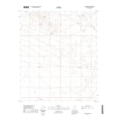
2023 Map of Ninetysix Ranch
USGS Topo · Published 2023About this map
Langford Mountains anchor the northern landscape of this Grant County terrain, where elevation shifts define the drainage patterns of the high desert. This 2023 survey by the U.S. Geological Survey illustrates a network of ephemeral water sources and seasonal washes essential to regional land use. Strategic water points such as Glaze Tank, Dons Tank, and Rincon Tank are distributed across the township, supporting the ranching operations that give the area its name. The land is dissected by numerous topographical features including Jones Canyon, New Well Canyon, and South Well Canyon. Human passage through this arid environment is facilitated by established routes like Separ Rd and Jones Ranch Rd, which navigate the draws of Smith Draw and Langford Draw. The presence of Ninetysix Creek in the southeast further emphasizes the vital role of intermittent hydrology in this corner of New Mexico.
Find a feature on this map
19 named features on this map. Tap any name to fly to it.
Don’t see what you’re looking for? This feature index may not catch every label — zoom into the map to look around manually.
Map Details
Editions of this 2023 Ninetysix Ranch Map
This is the sole edition of this map. No revisions or reprints were ever made.
Other maps of this area

1954 · Silver City
USGS Topo · 1:250,000

1958 · Silver City
USGS Topo · 1:250,000

1962 · Silver City
USGS Topo · 1:250,000

1962 · Ninetysix Ranch
USGS Topo · 1:24,000

1962 · Lisbon
USGS Topo · 1:24,000

1963 · Gold Hill
USGS Topo · 1:24,000

1963 · Soldiers Farewell Hill
USGS Topo · 1:24,000
1963 · Werney Hill
USGS Topo · 1:24,000
1963 · C Bar Ranch
USGS Topo · 1:24,000

1964 · Muir Ranch
USGS Topo · 1:24,000