
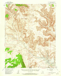
1953 Map of Nipple Butte
USGS Topo · Published 1956About this map
Nipple Butte rises as a prominent landmark in this high-desert plateau country during the early 1950s, defining a landscape marked by deep canyons and expansive benches. The terrain is characterized by the broad Nipple Bench and East Clark Bench, revealing a land where water sources like Alkali Seep, Wiregrass Spr, and the strategically placed Windmill were vital for survival and livestock. The map traces the winding paths of Wahweap Creek and Hatch Creek as they cut through the rock, alongside named drainages like John Henry Canyon and Tibbet Canyon. This era represents the region just prior to the massive hydrological changes brought by the Glen Canyon dam project. To the south, Cedar Mtn stands near the border, overlooking a network of cattle-country features including Jacobs Tanks and Lone Rock Creek.
Find a feature on this map
24 named features on this map. Tap any name to fly to it.
Don’t see what you’re looking for? This feature index may not catch every label — zoom into the map to look around manually.
Map Details
Editions of this 1953 Nipple Butte Map
2 editions found
Other maps of this area

1886 · Escalante
USGS Topo · 1:250,000

1886 · Echo Cliffs
USGS Topo · 1:250,000

1891 · Echo Cliffs
USGS Topo · 1:250,000

1922 · Warm Creek
USGS Topo · 1:63,360

1922 · Upper Last Chance
USGS Topo · 1:63,360

1922 · Rees Canyon
USGS Topo · 1:63,360

1951 · Lees Ferry NE
USGS Topo · 1:24,000

1953 · Gunsight Butte
USGS Topo · 1:62,500

1954 · Lees Ferry NW
USGS Topo · 1:24,000

1954 · Leche-E Rock
USGS Topo · 1:62,500