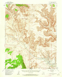
1953 Map of Nipple Butte
USGS Topo · Published 1962About this map
Nipple Butte rises above an intricate network of deep canyons and high mesas along the Utah-Arizona border. This mid-century survey documents the landscape during a period of transition, specifically highlighting areas intended to be submerged by the waters of Lake Powell at the 3700-foot elevation line. The drainage systems of Wahweap Creek, Warm Creek, and Coyote Creek carve through the plateau, defining the rugged topography of Nipple Bench and East Clark Bench.
Find a feature on this map
27 named features on this map. Tap any name to fly to it.
Don’t see what you’re looking for? This feature index may not catch every label — zoom into the map to look around manually.
Map Details
Editions of this 1953 Nipple Butte Map
2 editions found
Other maps of this area

1886 · Escalante
USGS Topo · 1:250,000

1886 · Echo Cliffs
USGS Topo · 1:250,000

1891 · Echo Cliffs
USGS Topo · 1:250,000

1922 · Warm Creek
USGS Topo · 1:63,360

1922 · Upper Last Chance
USGS Topo · 1:63,360

1922 · Rees Canyon
USGS Topo · 1:63,360

1951 · Lees Ferry NE
USGS Topo · 1:24,000

1953 · Nipple Butte
USGS Topo · 1:62,500

1953 · Gunsight Butte
USGS Topo · 1:62,500

1954 · Lees Ferry NW
USGS Topo · 1:24,000